Founded in 1773, Statens Kartverk is the Norwegian Mapping Authority. NMA is a public agency of the Ministry of the Environment responsible for Research and Development, surveying and mapping both land and sea, and generating and producing both digital and printed information (including loads of really cool maps).
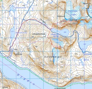
My dad and I traveled around Norway after I graduated from High School almost 10 years ago and visited many of our family members. My father´s mother´s family comes from a small place near Ålesund called Sæbø, which lies on the Hjørundford. This is an absolutely spectacular area that I hope to visit again sometime. In the meantime, I enjoy looking at the kart (map) of Hjørundfjord that my dad purchased and gave to me. It is an extremely detailed kart that shows høyde (elevation), and fjellnavn (mountain names). On these kart, you will find additional information with symbols indicating:
hytte og koie-cottage and cabin
gård og sæter-farm and chalet
skole-school
hotell-hotel
turisthytte-tourist hut (including betjent-staffed lodge, selvbetjent-selfservice chalet, and ubetjent-unstaffed hut)
sykehus-hospital
campingplass-campsite
kirke-church
gravplass-cemetary
kraftverk-power plant
tårn-tower
gruve-mine
grustak-gravel pit
skytebane-rifle range
foss-waterfall
stryk-rapid
fyr-lighthouse
sjømerke-beacon
høyde på vann-lake elevation
dyrket mark-cultivated land
park-park
frukthage-fruit orchard
myr-marsh
skog-forest
motorveg-motorway
sti-footpath
lysløype-illuminated ski track
bilferje-car ferry
passasjerferje-passenger ferry
jernbane-railway
tunnel-tunnel
riksgrense-international boundary, border
verneområde-nature conservation area
friområde-recreational area
And if that´s not enough information for you, knowing what the following words mean will help you read these kart as well:
bre-glacier
fjell-mountain
dal-valley
elv-river
grov-stream
horn, tind-peak
li-mountain, slope
vatn-lake
vik-cove
øy-island
I could seriously sit and look at kart like these for hours, dreaming about climbing all of the fjell and wandering around the fjords.
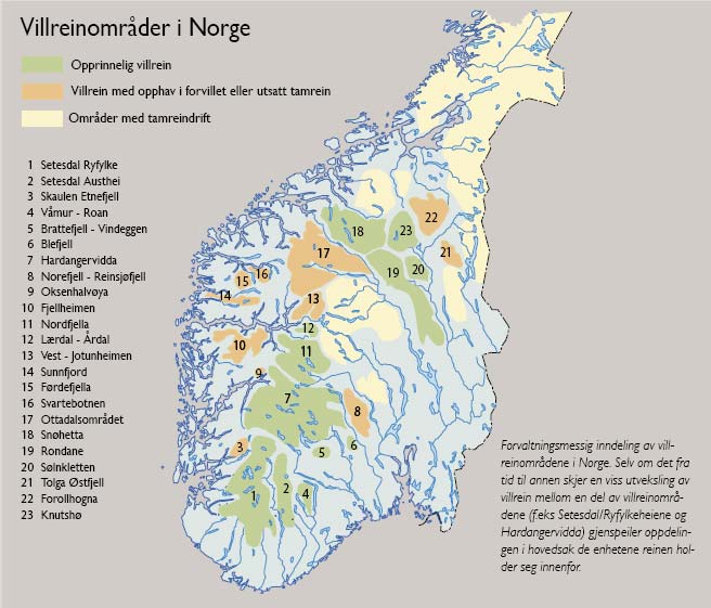
 This is a kart of villreinområder (wild reindeer areas)
If you would like to view the NMA website, click here to read it in Norwegian and here for English.